S260T
Photoelectric pod products

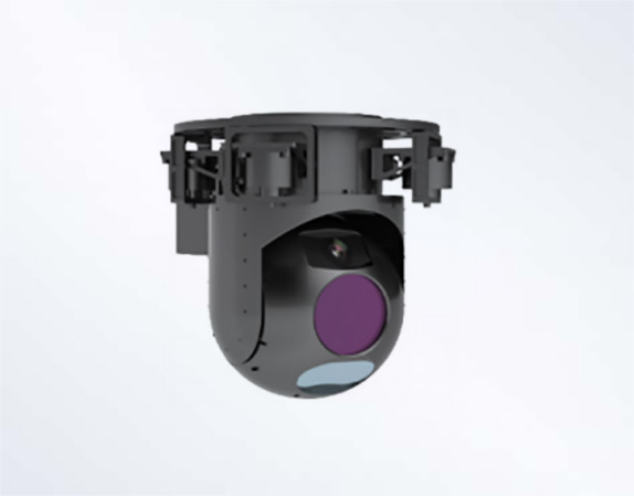
Product Description
The S260T two-axis three-light pod integrates a 640×480 high-resolution dual field of view infrared camera, a 30x optical zoom 1080P full HD visible light camera, a laser rangefinder with an operating distance of up to 5.0Km, and a high-precision INS and high-precision stabilization platform. The pod has high stabilization precision and it can precisely locate the tracking target. It can work during the day and night, and quickly investigate large areas or areas that are inaccessible to close-range detection personnel.
Product Features
· Large unmanned aerial vehicle (UAV), manned aerial vehicle, ship-mounted etc.
· It has the function of laser ranging.
· The function of calculating the target coordinates based on laser ranging and navigation measurement information;
· It has the ability to move in two degrees of freedom: Azimuth angle and Pitch angle.
· It has the function of receiving instructions from the control station and completing operations.
· The system enables two-way communication with the pylon fire control system via the RS-422 interface, and transmits target distance, pod attitude and velocity, and target coordinates.
· The system enables two-way communication with the control station via an Ethernet port, and outputs data including infrared images, visible light images, target distance, pod attitude and velocity, target coordinates, system operating status, camera operating status, optical axis position, and angular velocity information, as well as other relevant data.
· It has the ability to isolate carrier disturbances and stabilize the aiming line.
· It has the function of automatic target tracking, which can automatically track the target and has the ability to resist natural interference.
· It has the functions of focusing and adjusting the size of the wave gate.
· It has the functions of coarse and fine adjustment.
· It has the capability of long-wave uncooled infrared observation and visible light detection, and simultaneously output infrared images and visible light images.
· It has the function of pulsed long-term distance measurement of targets through laser under certain smoke conditions.
· It has navigation and positioning functions.
· It has the function of measuring the angular velocity and acceleration of a moving carrier.
· It has the functions of navigation calculation and attitude calculation.
· It has the functions of zero position self-calibration and self-alignment of the static base.
· It has the function of outputting pre-installed ephemeris.
· It has the function of dual GNSS antenna attitude measurement (heading Angle).
· It can receive control commands from the system and control functions such as pod pointing, pod scanning, target locking/unlocking, and target ranging;
· The system features target information output and video output functions, providing the display and control system with data including infrared images, visible light images, target distance, pod attitude and velocity, target coordinates, system operating status, camera operating status, optical axis position, and angular velocity information, as well as other relevant data.
· It has stowage function.
Applications
· Large unmanned aerial vehicle (UAV), manned aerial vehicle, ship-mounted etc.
Main technical indicators
|
Model |
S260T |
|
Infrared thermal imager |
|
|
Detector type |
Uncooled focal plane |
|
Detector resolution |
640×480 |
|
Wave band |
8~14um |
|
Pixel size |
17um |
|
Focal length of the lens |
25mm/100mm double field of view(F#1.0) |
|
Field of view |
24.9°×18.7°/6.2°×4.6° |
|
Visible light camera |
|
|
Resolution |
1920×1080 |
|
Focal length |
4.3~129mm |
|
Horizontal field of view |
63.7°~2.3° |
|
Optical Zoom |
30x |
|
Zoom Type |
Auto-focus |
|
Laser rangefinder |
|
|
Working band |
1.55um |
|
Maximum operating range |
≥5Km |
|
Minimum operating range |
≤100m |
|
Ranging accuracy |
≤5m |
|
Repetition frequency |
≥5Hz |
|
Servo platform |
|
|
Azimuth angle |
360°×n; |
|
Pitch angle |
-85°~+180°(Vertically downward is 0°) |
|
Maximum Angular Velocity |
Azimuth angle≥60°/s Pitch angle≥60°/s |
|
Maximum angular acceleration |
Azimuth angle≥100°/s² Pitch angle≥100°/s² |
|
Stabilization precision |
≤0.1mrad(1σ) |
|
Angular accuracy |
≤1mrad(1σ) |
|
Integrated Navigation Device Specifications (Optional) |
|
|
Navigate mode |
GPS/Beidou dual mode |
|
Horizontal Positional Accuracy |
≤3m |
|
Vertical Positional Accuracy |
≤8m |
|
Horizontal Attitude Accuracy |
≤0.15° |
|
Heading and Attitude Accuracy |
≤0.2° |
|
System parameter |
|
|
Tracking |
Automatic target tracking |
|
Supply voltage |
28VDC±4V |
|
Power consumption |
Steady state power consumption:≤100W Peak power consumption:≤250W |
|
Weight |
≤18.5Kg(exclude INS) |
|
Dimension |
261mm×261mm×431mm |
|
Control Interface |
RS422 |
|
Video Interface |
SDI、100M ethernet |
|
Environmental suitability |
|
|
Operating temperature |
-40℃~+55℃ |
|
Storage temperature |
-40℃~+60℃ |
|
Sealing grade |
Optical Chamber Hermeticity |


版权所有:Copyright © 2025 suncitygroup太阳新城(中国)集团官方网站 All Rights Reserved 备案号:渝ICP备17008919号-1 -技术支持:网润软件


